
General
Lupgar Pir Pass Trek (2026-27)
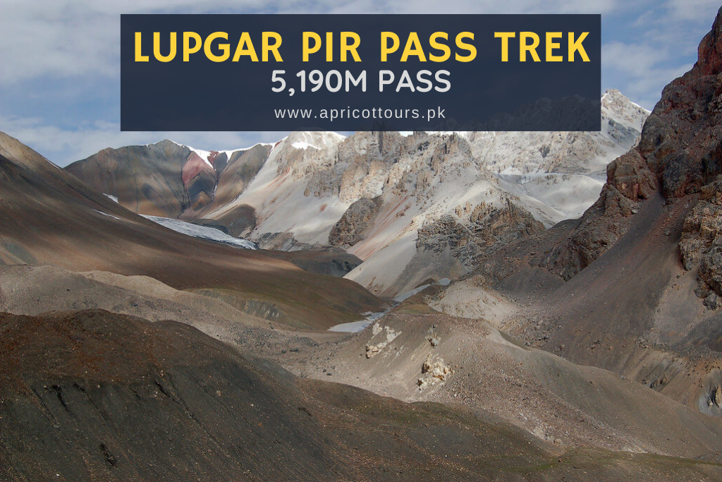
The Lupgar Pir Pass, tucked within the remote and breathtaking Karakoram mountain range, is a hidden gem that has long eluded trekkers and adventurers. This non-glaciated pass, at an elevation of 5190 meters, offers an experience unlike any other. Given below are the details of the Lupgar Pir Pass trek.
Dates & Cost – Lupgar Pir Pass Trek – (16 Days)
Summers are ideal for the Lupgar Pir Pass Trek. The start and end dates in the table below are your dates of arrival and departure from Pakistan. These months mentioned below are the ideal months for trekking in the Karakoram region of Pakistan. We have guaranteed departures every year. Our dates and costs for the Lupgar Pir Pass trek are given below.
| Start Dates | End Dates | Price (USD) | Availability | Deposit | Registration |
|---|---|---|---|---|---|
| 20-Jun-2026 | 05-Jul-2026 | US$ 2,100 | Limited Space | US$ 260 | BOOK NOW |
| 20-Jun-2027 | 05-Jul-2027 | US$ 2,200 | Available | US$ 260 | BOOK NOW |
| Start Dates | End Dates | Price (USD) | Availability | Deposit | Registration |
Holiday Information
- Licensed professional guide (government requirement)
- Airport transfers on the first and last day
- All road transport in Pakistan
- Hotel accommodation in Pakistan (twin sharing rooms)
- Trekking accommodation in Pakistan (twin sharing tents)
- Hotel meals in Pakistan (breakfast, lunch and dinner)
- Trekking meals in Pakistan (breakfast, lunch and dinner)
- Trekking logistics (tents, non-personal equipments and tools)
- Support staff (cook, assistant(s) etc)
- Porters for trekking equipments, kitchen (supplies, tools, equipments, crockery, gas) and personal luggage
- Travel Insurance (recommendations only)
- Visa to Pakistan (supporting documents offered)
- International airfare
- Personal equipments (list provided on registration or request)
- Tips for guides, porters, staff etc
- Miscellaneous (drinks, phone calls, laundry, souvenir etc)
Highlights – Lupgar Pir Pass Trek
Lupgar Pir Pass has a lot to offer. Given below are the main highlights of Lupgar Pir Pass trek.
- Karakoram mountain range
- Elevation at 5190 meters above sea level, providing stunning panoramic views of the surrounding valleys and peaks.
- Passing through picturesque valleys and meadows.
- Stunning rock formations, snow-capped peaks, glacier-fed streams, and vibrant meadows.
- Cultural Significance Insights into local livelihoods and traditions.
- Diverse terrain, including steep ascents, glacier crossings, and narrow trails.
- Untouched Wilderness is relatively undiscovered, offering an unspoiled trekking experience.
- A must-see destination for adventurers and nature enthusiasts.
- Meet mountaineers at base camps
- Sightseeing in Gilgit and Islamabad
Itinerary – Lupgar Pir Pass Trek
The itinerary for Lupgar Pir Pass trek is given below.
Day 02: Fly to Gilgit or drive to Chilas if the flight is cancelled
Participants on this morning will take the spectacular flight from Islamabad airport to Gilgit airport. You will be able to see Nanga Parbat if clouds allow. After arrival in Gilgit, the day is free.
The domestic flights sometime get cancelled due to weather conditions. Incase of flight cancellation, you will drive to Chilas for overnight. It takes eight to ten hours by a vehicle.
Day 03: Drive to Hunza - Hotel
The trip from Gilgit to Hunza is one of the world's most spectacular highways, with stunning vistas of the Karakoram mountain range. As you travel along the Karakoram Highway, you'll pass through several tiny towns and villages, each with its own distinct charm. Make sure to stop at the Rakaposhi Viewpoint for a breathtaking glimpse of Rakaposhi Peak, one of the world's tallest mountains.
Day 04: Enjoy a free day in Hunza
The day in Hunza allows you to discover the beauty and culture of this region. You might start by seeing the Baltit Fort, a UNESCO World Heritage site, or go to the breathtaking Attabad Lake. Alternatively, you may trek up to the Eagle's Nest, which offers a spectacular view of the surrounding mountains. Whatever you decide to do, you will have a fantastic day in Hunza.
Day 05: Drive to Yishkuk
In the morning, travel from Hunza to Yishkuk, a little village about three hours distant. Along the trip, you'll travel through beautiful scenery, with towering mountains on one side and lush green valleys on the other. Make sure to stop at some of the lovely sites along the way to enjoy the amazing views. Once you arrive in Yishkuk, spend some time exploring the village and interacting with the residents to learn about their way of life and culture.
Day 06: Trek Yishkuk to Raud
Yishkuk (3450 metres) is a well-watered willow meadow. A pleasant spring runs alongside the road right before you reach Yishkuk, where zolg (Berberis) shrubs with excellent blueberries and wild rose bushes bloom. Leave the road before it starts to climb towards the Yishkuk torrent's wooden bridge. Walk south valley through moraine rubble, with the Wyeen Glacier's outwash stream to the west. The trail is lined by scarce juniper trees. After 30 to 45 minutes, the trail swings southeast and arrives to a level area, primarily a stand, next to a large, very cold, clear brook. The stream is fed by a spring located at the base of a south-facing scree slope. Raud (3600 metres) is a wonderful camping spot. To the west, above the 20-kilometer-long Yishkuk Glacier, is Sekr, a remarkable red rock with a summer settlement at its base. Although this is a short walk, most hikers need to acclimatise before proceeding.
Day 07: Raud to Wyeen
Cross the clear stream and walk five minutes down its true left side to the two-part wooden footbridge that spans the massive glacier torrent. Ascend 30 minutes above the river's true left bank through junipers on a tiny, clean herder's route to the Kit-ke-zherav (3690m) cottages and livestock corral. You can get to the tiny Kit-Ke-zherav stream from the south in five minutes. Cross it and proceed 45 minutes up the steep, rocky ablation valley to Shot Dur (3780m, or 'avalanche valley'). This is the glacier's final source of water. Continue up the valley, eventually climbing out to contour the green hillside, and in 45 minutes, you'll arrive at a dark talus slope.
Cross Charva Shui, a greasy black talus at 3990 metres, in 15 minutes. Return to the ablation valley and slowly climb for 30 minutes till the valley bends south.
Over the Wyeen Glacier to the east, there is a side valley marked by red sandstone. Wyeen camp is the grassy meadow seen between two small ridges to the south. The glacier can be crossed in two hours. The glacier's rock is mostly stable, making the crossing uncomplicated. Continue north (left) of two enormous white and brown debris mounds in the glacier's core. Only one or two tents can be set up near the cabins at Wyeen (4100m), with a few more on rooftops. Larger trekking groups. Camp beside the glacier stream that flows from Banafshayeen.Clear water can be found directly above the livestock pens.
Day 08: Wyeen to Haji Beg Camp
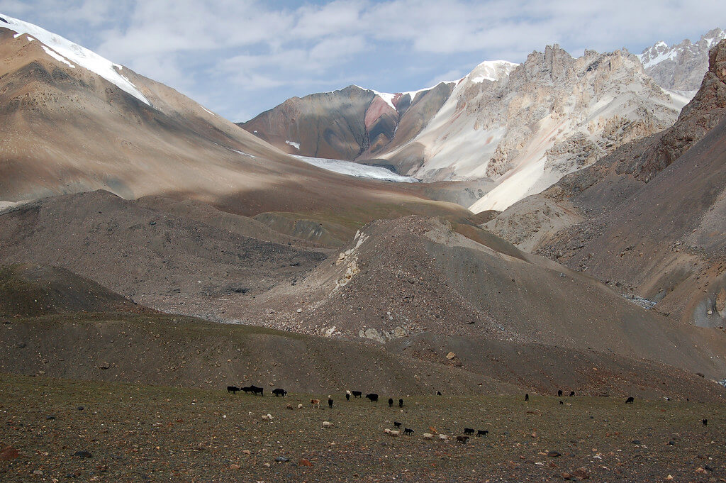
Cross to the actual left bank of the Banafshayeen Creek. Spend an hour climbing Wyeen Glacier's lateral moraine on loose boulders. After leaving the moraine, walk along the bank of the creek. Cross the Banafshayeen Valley's true left bank just below the mouth (4200m). A large hiking party could set up camp across the silty stream in an open area near a small moraine lake. In 30 minutes, ascend the grassy slope to the level of Banafshayeen Valley (4410 metres). The view from Kuk Sar (6943m) and its 3000m steep cliff is magnificent. The highest pasture used by Wyeen herders is named Banafshayeen, which translates to "the place where banafsha (Primula macrophylla) grows."
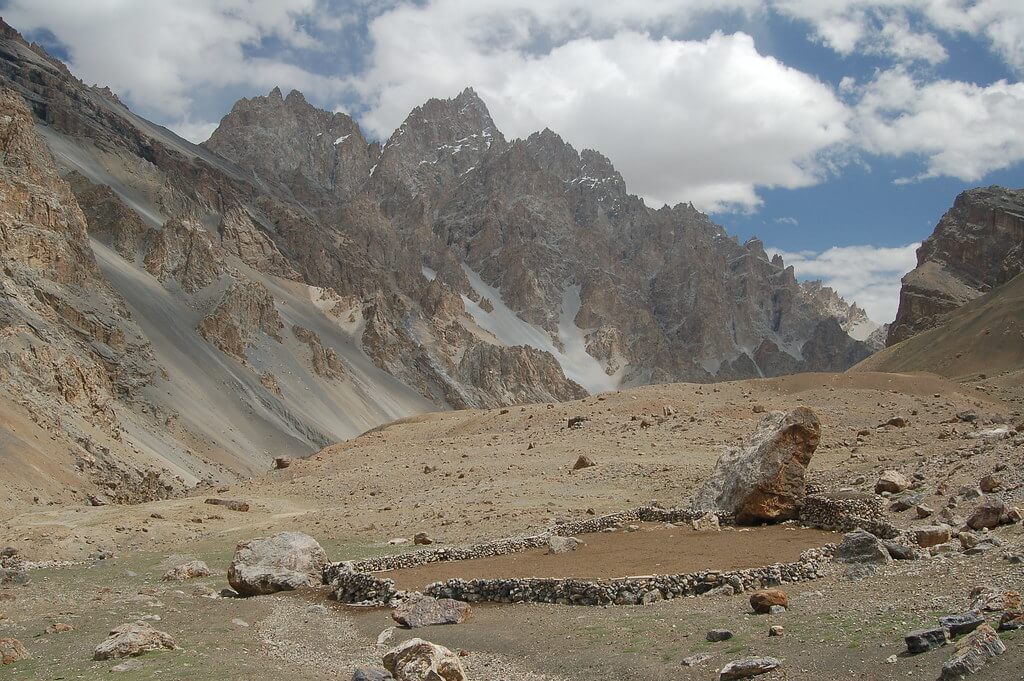
There are no pathways or cairns past this point. Proceed gently up the actual right bank of the stream. An unexplained glacier (4650m) that covers the valley ends an hour above the Banafshayeen meadow. The Swiss map does not show this glacier; instead, it depicts two smaller glaciers higher up the valley. These glaciers have amalgamated and dropped to the location on the map where their outflow streams intersect. Skirt the glacier far above its northern edge. A 45-minute hike up the black lateral moraine leads to a small side valley with a clear stream. Continue high above the glacier for another hour until you reach a second-side valley with a larger, clean stream flowing down. Ascend for five to ten minutes along this stream to a vast level area where the remains of a square enclosure beside a large, prominent boulder indicate that others had gone this route. The writers named Haji Beg Camp (4680m) in 1994 after a travelling buddy who embodies the essence of these mountains. The scenery is breathtaking, and the pass can be seen from the top of this side valley.
Day 09: Haji Beg Camp to Wyeen
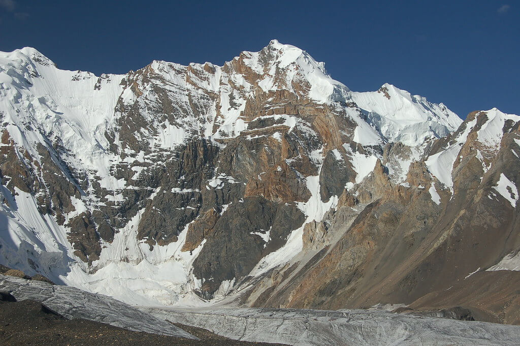
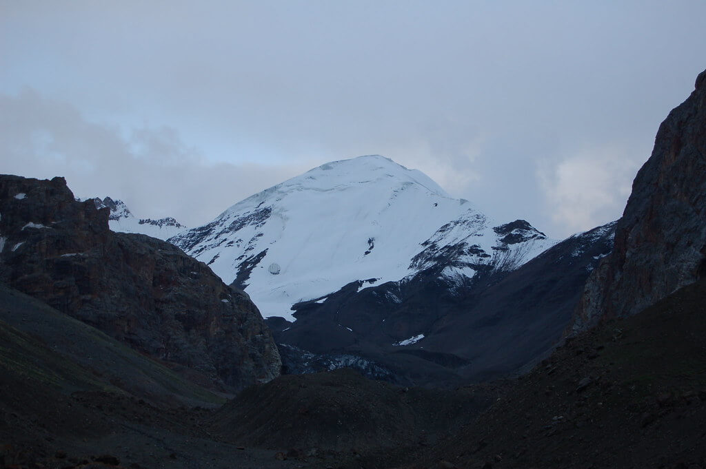
Follow the stream one to two hours north-east to its head (5100m), then 30 minutes east-northeast up higher scree to the Lupgar Pir Pass (5190m). By mid-July, the pass is typically snow-free. Beyond Kuk Sar to the southwest, Pamir Sar (7016m) is visible, which Schomberg describes as a "series of superb peaks and glaciers."
Descend steep, loose scree to a scree knoll, then cross the knoll to the left and descend to a glacier. The 300-meter descent takes between 15 and 30 minutes. To avoid crevasses, follow a zigzag trail out onto the white glacier. For 30 minutes, work across and slightly down the glacier's 15- to 20-degree slope to a little black medial moraine. Continue to the terminal moraine, which includes a few pools. More pools can be seen about 500 metres below the glacier's snout. Rather than descending towards the river's mouth, stay high and go right on scree, well above the river, for 30 minutes to a clear stream, then 15 minutes to Wyeen (4530m).
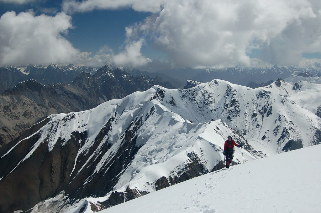
The upper Lupgar Valley is notable for its striking red, yellow, and brown rock formations. Climbers could be interested in the valley's snowy 6000m peaks, which appear to be simple ascents.
Day 10: Wyeen to Hoopkerch
Drop down to the main river bed and follow the faint trail. In 15 minutes, you'll reach the massive outwash torrent from the huge glacier to the south. It contains a lot of knee-deep rivers. Continue one hour across the creek to Ilga (4380m), a grassland with a few abandoned buildings. In the afternoon, water from a hanging glacier is exceptionally silty. The north side of the valley has stunning snowcapped spires with scree pouring from their bases to the river. Its south side boasts spectacular crimson crags.
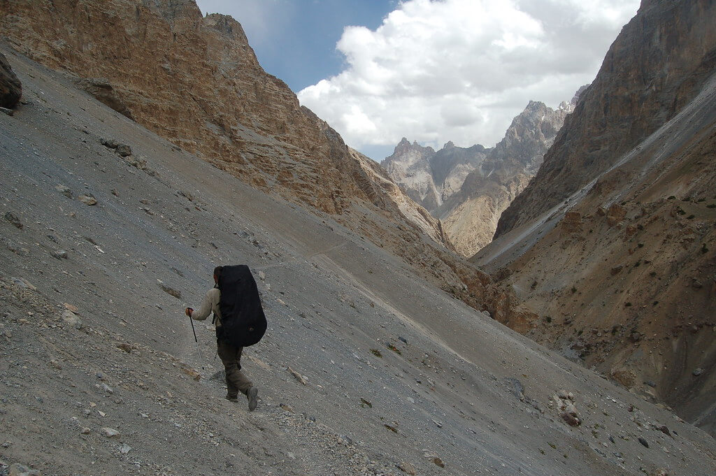
Descend 20 minutes to Ghorhil, a natural cow corral (hil) in the middle of a boulder field (ghor). The water is dirty. Descend around 15 minutes via steep boulders to a river that flows in from the south. Cross the river and head to Lupgar (4140m, 'big rock'), the main summer destination for Khaibar and Raminj herders who share grazing rights in this area. A small spring can be discovered at the bottom of a cliff to the south. When leaving Lupgar, keep near the cliffs. 15 minutes from Lupgar, cross a southern side stream across a stone footbridge and descend for 30 minutes to the Lupgar River. Two-thirds of the way down, on the left, is a huge spring that provides the last reliable pure water till Raminj. Cross the river via an interesting footbridge and continue along the true left bank, passing Khuda Khair Charjeshan, the 'God assist us slides'. Rockfall along this trail is dangerous in wind or rain because it is so narrow and exposed.
After 45 minutes, the hike leads to a natural footbridge. The gorge is so deep and narrow that the river below is hidden. After reaching the actual right bank, continue on a tiny, loose trail with a tough footbridge. Continue down the valley, crossing two side creeks. The water in one is crimson, whereas the water in the other is light. Descend for an hour to a sandy riverside, passing through a birch wood before ascending to a juniper forest.
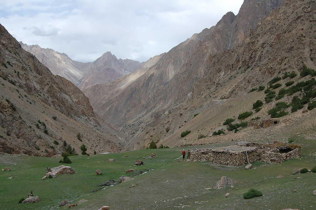
Hoopkerch (3700m, "seven hunters' houses") is ahead and below 15 minutes, where a glacier-side stream enters from the south. A small spring is found beneath the livestock fence.
Day 11: Hoopkerch to Raminj
Cross the muddy stream over a footbridge and walk for an hour through the beautiful ancient juniper woodland to Harkeesh (3489m, the 'place farmed with a plough'). Harkeesh is the valley's unique Burushaski place name, given by a Raminj Burusho who sought to cultivate it. Harkeesh's Wakhi name is Kishtazod. The well-built home and livestock enclosure are surrounded by a vast, open grassy area suitable for camping. The canyon walls lead to cliffs topped with huge, multicoloured stone peaks, spires, and turrets. The Werthum Pass route ends here (see p). The water in the side stream could be silty. Descend sharply from Harkeesh for 10 minutes before crossing a side creek via a footbridge. Birches, roses, tamarisks, and junipers grow abundantly in Furzeen (Purzin on the Swiss map). In five minutes, you can cross a robust footbridge to the left bank of the Lupgar River. The trail from here to Raminj is greatly improved, albeit it remains exposed in places. For the next 114 to 112 hours, the trail climbs high above the river valley before dropping down to the Raminj canal's headworks. Midway, cross a footbridge to the actual right bank of the Lupgar River, above the confluence of the Lupgar and Dior rivers, which leads to the Dior hut. Follow the willow-lined canal for an hour to Raminj, passing several gushing springs along the way. The canal, built during Mir Muhammad Jamal Khan's reign and finished in 1978, is a marvel of engineering. Several tunnels cut into the rock carry the canal beneath the scree slopes that the trail follows. Raminj (3095m), situated at the confluence of the Lupgar and Chapursan rivers, is a charming, well-kept village with east and south exposures.
Day 12: Drive to Sost - Tent
Your journey to Sost begins in Raminj and continues over the well-known Karakoram Highway. This picturesque trip lasts about 1.5 to 2 hours and provides amazing views of the surrounding mountains and valleys. Along the trip, you'll pass through a number of attractive villages and towns, each with its own unique perspective on local culture and customs. As you approach Sost, the scenery gets increasingly harsh and steep, with the town snuggled between towering peaks. When you arrive in Sost, take some time to explore the town's busy streets and vivid markets before retiring for the evening.
Day 13: Drive to Gilgit - Hotel
The drive to Gilgit from Sost takes about 3 to 4 hours and offers wonderful views of the enormous Karakoram range. As you drive across this rocky landscape, you'll come across a variety of little towns and villages, each with their own distinct charm. Keep your camera handy, as there will be numerous opportunity to photograph the breathtaking views. Once you arrive in Gilgit, spend some time exploring the city's busy marketplaces and historical attractions before retiring for the night.
Day 14: Fly to Islamabad or drive to Chilas - Hotel
GPS Data
Altitude: 538 m
On this day the participants will take a flight from the airport in Gilgit to Islamabad aiport. You will have a good time to relax at the hotel in Islamabad.
The domestic flights sometime get cancelled due to weather conditions. Incase of flight cancellation, you will drive to Chilas for overnight. It takes eight to ten hours by a vehicle.
Day 15: Contingency day for flight cancellation
This day is allocated for any potential delays in case the domestic flight does not operate the previous day. Our guests will depart early morning from Chilas to Islamabad which can take up to ten hours. However it will be a free day in case the participants make it to Islamabad on the domestic flight. This time can be utilized for sightseeing in Islamabad.
Day 16: Fly to Home country
Meals included: Breakfast
Our staff will transfer all our guests to the airport on their respective departure timings. The checkout time of all our partner hotels is 12pm.
Why Register Early?
1. Early Bird Discount: The given prices for the holiday are limited-time discount offers and are subject to change. Service providers including (but not limited) to airlines and hotels increase prices in peak-season. Early reservations cost less than peak-season.
2. Limited Flight Seats: Domestic flight seats to the Karakorams and Himalayas are sold out way ahead of time because there are only two daily flights during peak season. Among other things, the deposit is used to book domestic flights for you in advance.
3. Pay Balance after arrival in Pakistan: In these unusual times, we appreciate that paying the final balance for your trip may cause concern. Our policy is to only receive your final balance once you arrive in Pakistan. The only payment before arrival is the deposit.
4. Deposit valid for 3 years: We understand the uncertainty surrounding the pandemic (Covid-19). As part of our relaxed booking conditions following Covid-19, deposits are valid for 2 years.
6. Pay Minimum Deposit: The deposits for the holiday are also early-bird discounts and automatically change accordingly:
- 1st October: USD 190
- 1st November: USD 290
- 1st January: USD 350
- 15th February: USD 400
- 1st March: USD 450
- 1st May: USD 490
Note: The same dates above apply to next season's deposits.
Refund Policy for All
Deposit: Once paid, the deposit is non-refundable (but valid for 2 years) as it will be spent on making in-country arrangements.
Balance: Pay the balance only after arrival in Pakistan on the first day. Payment guidelines will be shared timely.
Currency
All international travelers can pay in US Dollars (USD) or equivalent in Euros (EUR) or Pound Sterling (GBP). Pakistani travelers are charged the equivalent in Pakistani Rupees (PKR).
Single Supplement
Separate hotel rooms (single supplement) will cost an additional USD 290. This includes all hotel nights. This payment should be made with the balance upon arrival.
Separate tents (single tent) will cost an additional USD 180. This includes the cost of additional porterage. This payment should also be made with the balance in Pakistan.

As Featured In:


| Apricot Tours' Social Responsibility |
| 1 foreign trekker = 5 trees |
| Apricot Tours will plant five trees for every foreign trekker who visits Pakistan for trekking to Nanga Parbat. The trees will be planted in the northern areas of Pakistan starting from 2019 as part of our CSR initiative. We aim to contribute to "Goal 13: Climate Action" of UN's Sustainable Development Goals by taking part in the massive government campaign to plant 10 billion trees during the next five years to tackle climate change. Pakistan's adverse climate impacts are very much visible through changing temperatures, prolonged droughts, increased floods and extreme weather conditions especially in Pakistan's mountain regions. Pakistan stands 7th on the list of countries that are mostly likely to be affected by global warming and has one of the highest deforestation rates in Asia. Decades of tree felling have reduced the country's forests to less than 3 percent of its total land area. How planting trees will make a difference? Planting trees will help save energy and money, cool our cities, reduce carbon emissions, reduce soil erosion, provide habitat for species of many kinds, provide clean water and add to the beauty of Pakistan's mountain region by simply being there. Our participants can also donate separately. Details on this initiative can be requested. |
Lupgar Pir Pass Trek – Overview
The Lupgar Pir Pass trek is a well-kept mystery that hikers and explorers have long overlooked. It’s located in the remote and majestic Karakoram mountain range. With an elevation of 5190 meters, this non-glaciated pass provides an experience unlike any other. It follows a road that borders the southern limit of the Chapursan Valley, connecting Raminj in the hilly and scenic Lupgar Valley to Yishkuk in the upper Chapursan Valley.
For years, the locals in this area have used these valleys largely for cattle grazing rather than exploring the history. This passage did not return to the world of exploration until 1994, implying a “reopening” of sorts. The recent crossing in 1994 followed in the footsteps of Schomberg’s 1934 expedition, reigniting the pass’s allure for trekkers and mountaineers alike.
Lupgar Pir Pass trek allows daring travelers to climb this beautiful mountain via two distinct approaches. Because Yishkuk lies 300 meters higher than Raminj, the west-to-east route allows for a more gradual acclimatization period. Furthermore, the west side of the pass has a shorter and less scree-filled ascent than the east. The non-technical glacier treks on this route provide an element of excitement and hardship to those who dare to go on this journey.
Lupgar Pir Pass trek is a testament to the Karakoram’s enduring allure, an invitation to explore its wild landscapes and cultural intricacies. It remains a hidden treasure, waiting to be discovered by those seeking the pristine beauty and undiscovered experiences that the mountains have to offer. Its allure rises with each passing year, cementing its reputation as a must-see destination for those seeking the thrill of the unknown.
Website Last Updated: January 15, 2026